In this lesson, students interact with local stories and datasets of five natural hazards in Lake County; drought, wildfire, flood, landslides and earthquakes. Students investigate the connections between wildfire and landslides with a hands-on lab, then develop a concept map to show their understanding of the connections between these hazards.
Context for Use
In the second lesson of the Lake County Cascading Hazards unit, students dig into local stories and datasets, and learn about the connections between natural hazards.
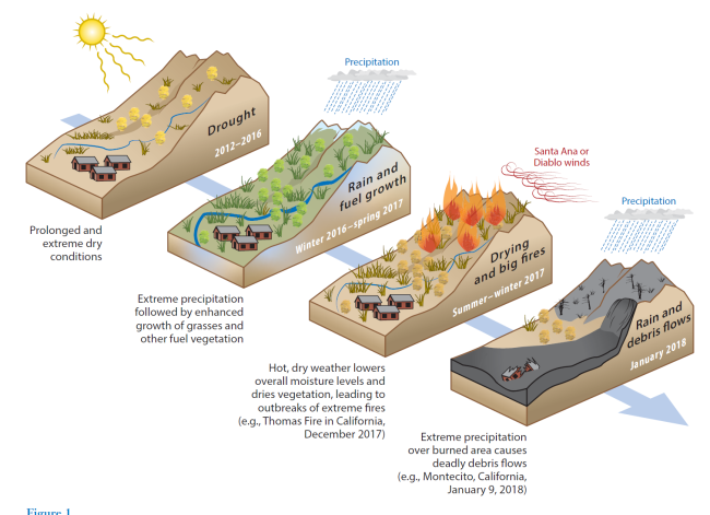
Project scientist Amir AghaKouchak and his colleagues developed this figure showing how one hazard led to another in Montecito, CA (AghaKouchak et al 2020).


Goals Header
What Students Will Do
- Interpret spatial datasets of environmental conditions that can be the cause of natural hazards.
- Plan and carry out an investigation of how wildfires can cause landslides.
Teaching Materials
Description
In this lesson, students will:
Part 1 – (15 minutes) Cascading Hazards Concept Map Warm-Up
Formulate their initial ideas about the four hazards, the conditions that lead to them, and how they are connected.
Part 2 – (65 minutes) Cascading Hazards StoryMap
Read and engage with a StoryMap, and answer questions on a separate worksheet.
Part 3 – (70 minutes) Lab: How Can Wildfires Lead to Mudslides?
Plan and perform an investigation to explore what happens during a rainstorm on a mountain slope before and after a wildfire.
Part 4 – (20 minutes) Cascading Hazards StoryMap: Continued
Continue to read the StoryMap, and finish answering questions about the StoryMap.
Part 5 – (50 minutes) Explore Current Environmental Conditions
Interact with maps from the StoryMap to investigate current environmental conditions, and what hazards might be a current threat in the community.