Science of Smog
CIRES & NOAA air-quality research in Colorado*
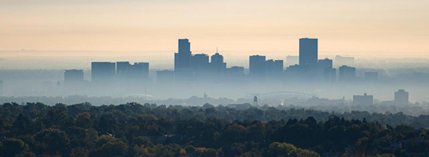
Every summer along Colorado’s Front Range, ozone pollution periodically spikes to unhealthy levels, despite federal and state efforts to control the lung-damaging chemical. Cars are running cleaner, and power plants are emitting fewer pollutants, so why does ozone still regularly soar above health-based limits?
This July and August, nearly 200 scientists from several national and regional agencies will focus sophisticated instruments on the Front Range atmosphere, seeking to better understand the sources of emissions and the chemistry that contribute to regional air-quality challenges. Ultimately, the goal is to share discoveries with decision makers seeking to clear the air.
When ozone levels spike, Environmental Protection Agency (EPA) experts recommend that people, especially those in sensitive groups—children, the elderly, and anyone with pre-existing respiratory conditions—limit time outdoors. Seven years ago, Colorado’s Front Range fell out of compliance with federal regulations designed to protect people’s health.
The National Center for Atmospheric Research (NCAR) and NASA are leading the Front Range air-quality missions this summer, and an array of aircraft will make detailed atmospheric measurements, supported by other instruments on the ground. CIRES and NOAA scientists are contributing primarily with ground-, tower-, vehicle-, and balloon-based instruments, as outlined below.
- Sun-tracking measurements
- Towering measurements
- Agriculture matters
- Methane and more
- Balloon-based measurements
- Air-quality education and outreach
- The broader efforts
Sun-tracking measurements
CIRES Fellow Rainer Volkamer and colleagues will use a 10-foot-tall mobile laboratory, equipped with innovative, custom-built sensors, to explore variations in the gas column between the vehicle and the sun in space and time. Volkamer’s Multi-Axis Differential Optical Absorption Spectrometer and the novel mobile Solar Occultation-Flux Fourier Transform Infrared Spectrometer rely on sunlight to measure hydrocarbons, ammonia, and nitrogen dioxide molecules located between the van and the sun. These gases are emitted from oil and gas activities, feedlots and dairy farms, and urban sources and undergo chemical reactions in the atmosphere that form unhealthy ozone and aerosols. By combining mobile column measurements with wind patterns, the team’s work will help clarify the contributions of cities, oil and gas activities, and regional weather patterns to regional air-quality challenges.
Contacts: roman.sinreich@colorado.edu, rainer.volkamer@colorado.edu
Towering measurements
At a 985-foot-tall tower in southwest Weld County, Colorado, a research team led by NOAA’s Steve Brown plans to simultaneously measure a suite of chemicals that contribute to ozone pollution; and they also will measure ozone itself. Brown and his colleagues at NOAA, CIRES, and Colorado State University will continuously make chemical and meteorological measurements over the height of the tower, once every 15 minutes. From these data, the scientists should be able to better understand sources of different air pollutants and the efficiency with which they produce ground-level ozone.
Contacts: steven.s.brown@noaa.gov, evf@rams.colostate.edu (Emily Fischer), delphine.farmer@colostate.edu
Agriculture matters
Scientists and air-quality experts on Colorado’s Front Range know that farming and ranching can degrade regional air quality, and can have other effects on the atmosphere, too, including climate effects. But there are scant reliable data on just what kinds of agricultural activities emit what kinds of airborne chemicals. Crop types, feedlot practices, fertilizer-application techniques, and other factors likely affect those emissions. NOAA scientist Tom Ryerson, CIRES researcher Jeff Peischl, and others will drive an instrumented van around agricultural areas of the Front Range and northeastern Colorado this summer, to collect detailed emissions measurements from specific agricultural sources. The effort should help scientists and decision makers better understand if there are agricultural management practices that minimize negative impacts to the atmosphere.
Contacts: thomas.b.ryerson@noaa.gov, jeff.peischl@noaa.gov
Methane and more
In 2008, a group of CIRES scientists built a “mobile laboratory” out of a Prius, outfitted it with several instruments, and began driving downwind of oil and gas wells and tanks, wastewater treatment plants, and feedlots in northeastern Colorado, sniffing out air emissions. Gabrielle Petron and her team, based out of NOAA's Earth System Research Laboratories, were especially interested in emissions of methane, a potent greenhouse gas. Since then, they have shifted to a van (more space for instruments and air canister samples) and have deployed their mobile laboratory to oil and gas basins in three states. This summer, their work will continue to focus on methane and other volatile organic compounds, some of which may contribute to air-quality challenges in the region. They will drive downwind of oil and gas facilities, landfills, agricultural operations, cities, and other sites, aiming to identify key sources of methane and other air pollutants, including possible “large emitters” responsible for a disproportionate share of pollutant emissions.
Contact: gabrielle.petron@noaa.gov
Balloon-based measurements
Ozonesondes are weather balloons that can loft ozone-measuring instruments 20 miles into the atmosphere. In support of the NASA and NCAR aircraft missions this summer, NOAA’s Bryan Johnson and colleagues in the Earth System Research Laboratories will make measurements with conventional ozonesondes and also “tethered balloons,” which can be winched up and down from the surface to 1,000 feet high, measuring ozone along the way. Since some aircraft flying in the mission won’t be cruising lower than 1,000 feet, the balloon-based measurements will help scientists understand what’s happening below that, enabling them to create a detailed, four-dimensional picture of how ozone pollution builds up on Colorado's Front Range in the summertime.
Contact: bryan.johnson@noaa.gov
Air-quality education and outreach
As part of this summer’s air-quality missions, hikers will measure air pollutants along trails with Boulder Open Space & Mountain Parks naturalists. NCAR interns will monitor air quality on hikes from trailhead to tundra in Rocky Mountain National Park. CIRES is collaborating with other agencies to host an air-quality workshop for educators, August 6 and 7. Members of the public are welcome at an open house at the NCAR Research Aircraft Facility, August 2, and at the Denver Museum of Nature and Science’s free day on July 20.
Learn more:
http://bit.ly/1oLXkR5 (registration, educator workshop)
http://www.naturehikes.org
http://cires.colorado.edu/education/outreach/projects/air_quality.html
https://www.eol.ucar.edu/frappe/eo
Contact: jennifer.l.taylor@colorado.edu
*The broader efforts
Support and expertise for the 2014 air-quality work on the Front Range come from NASA, the National Center for Atmospheric Research, the Colorado Department of Public Health and the Environment, the National Science Foundation, the EPA, the National Oceanic and Atmospheric Administration (NOAA), CIRES, CU Boulder, Colorado State University, and many other universities.
- NASA’s DISCOVER-AQ (Deriving Information on Surface conditions from Column and Vertically Resolved Observations Relevant to Air Quality). More: http://www.nasa.gov/mission_pages/discover-aq
- NCAR’s FRAPPE (Front Range Air Pollution and Photochemistry Experiment). More: https://www2.acd.ucar.edu/frappe
For more information on CIRES and NOAA involvement, please contact:
Kristin Bjornsen, CIRES science writer, kristin.bjornsen@colorado.edu, 303-492-1790
The Cooperative Institute for Research in Environmental Sciences (CIRES) is a partnership of NOAA and the University of Colorado Boulder.