Scientists probe methane emission mystery in Four Corners region
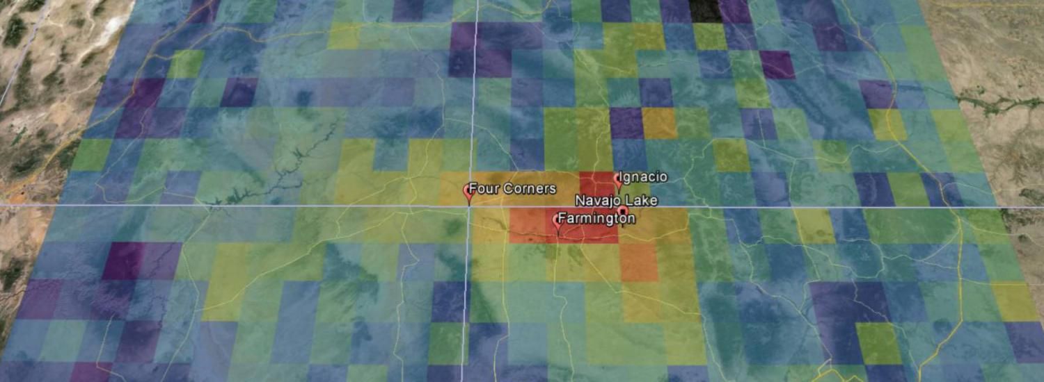
Satellite pinpointed methane hotspot in remote region
A team of scientific investigators is now in the Four Corners region of the U.S. Southwest, aiming to uncover reasons for a mysterious methane hotspot detected from space by a European satellite. The joint project is working to solve the mystery from the air, on the ground, and with mobile laboratories.
“If we can verify the methane emissions found by the satellite, and identify the various sources, then decision-makers will have critical information for any actions they are considering," says Gabrielle Pétron, a scientist from the Cooperative Institute for Research in Environmental Sciences at the University of Colorado Boulder, working in NOAA’s Earth System Research Laboratories (ESRL) and one of the mission’s investigators. In fact, part of President Obama’s recent Climate Action Plan calls for reductions in U.S. methane emissions.
Last fall, a team of researchers reported that this Southwest hotspot of methane was the largest U.S. methane signal viewed from space. An instrument on a European Space Agency satellite measuring greenhouse gases showed a persistent atmospheric hotspot in the area between 2003 and 2009, which was also detected by light aircraft measurements in the summer of 2014. For the current study, the Japanese GOSAT satellite, which measures methane, has been re-programmed to focus on the Four Corners region.
The satellite observations were not detailed enough to reveal the sources of the methane in the hotspot. Likely candidates include venting from oil and gas activities, including liquid unloading for coalbed methane extraction; active coal mines; and natural seeps.
Researchers from CIRES, NOAA, and University of Michigan (U-M) planned a field campaign called TOPDOWN (Twin Otter Projects Defining Oil Well and Natural gas emissions) 2015 to bring instruments to the region this spring to investigate possible sources of the methane hotspot, and now they will be joined by others from NASA and elsewhere. “This is a grassroots effort which has brought in funding from multiple agencies to multiple investigators to better understand methane emissions from the Four Corners using an array of methods,” said Eric Kort, one of the mission’s investigators from U-M.
The team will take a closer look at this region using airborne and ground-based instruments. The groups are coordinating their measurements, but each partner agency will deploy its own suite of instruments.
From the end of March through May 1, NOAA, CIRES and U-M researchers will cover the Four Corners area with many platforms and instruments. A NOAA Twin Otter will quantify methane emissions from the region. Two mobile labs—vans outfitted with sophisticated chemical detection instruments—will target specific areas identified by the aircraft to further characterize sources responsible for methane signals. A highly maneuverable, single-engine Mooney TLS airplane will survey the region to locate large methane signals and focus on particular methane plumes to quantify emissions at the facility-level.
As part of another NOAA field campaign, the SONGNEX (Shale Oil and Natural Gas Nexus) 2015 field mission, the NOAA P3 aircraft will also sweep over the area for one or two research flights, capturing information on a suite of chemicals associated with air quality and climate. Winds over the region will be monitored by an array of upward-viewing NOAA wind profilers and a laser wind-measuring instrument.
From April 17 through 24, a team from NASA's Jet Propulsion Laboratory (JPL) in Pasadena, California, will fly two complementary remote sensing instruments on two Twin Otter research aircraft. The Next-Generation Airborne Visible/Infrared Imaging Spectrometer (AVIRISng), which observes spectra of reflected sunlight, flies at a higher altitude and will be used to map methane at fine resolution over the entire region. Using this information and ground measurements from the other research teams, the Hyperspectral Thermal Emission Spectrometer (HyTES) will fly over suspected methane sources, making additional, highly sensitive measurements of methane.
With the combined resources, the investigators hope to quantify the region’s overall methane emissions and pinpoint contribution from different sources. They will track changes over the course of the month-long effort and study how meteorology transports emissions through the region.
"This joint campaign is a win-win for all participants," said Christian Frankenberg, a JPL scientist who is heading NASA's part of the effort. "It is a unique opportunity to characterize the region's methane budget using both remote sensing and local measurements in a coordinated effort."
The TOPDOWN 2015 mission is primarily funded by NOAA's Climate Program Office, with additional support from the National Science Foundation (Air Water Gas), NASA and the Bureau of Land Management.
The research team includes scientists from CIRES, NOAA ESRL’s Global Monitoring Laboratory, Chemical Sciences Laboratory, Physical Sciences Laboratory, NASA’s Jet Propulsion Laboratory, the Institute of Arctic and Alpine Research at the University of Colorado, Boulder, the University of Michigan, Bureau of Land Management, and the state of New Mexico.
More on the web:
- TOPDOWN mission
- NOAA story
- CIRES oil/gas backgrounder
- Four Corners Public Science Forum on Methane, April 17, Farmington, NM (agenda in PDF format)
- Kort et al, Four Corners: The largest US methane anomaly viewed from space, GRL, 2014
Download high-resolution images: