Scientists discover land subsidence may contribute more to coastal flooding than previously thought
The new work combines methods to create high-resolution flood projections in Lagos, Nigeria

Scientists in CU Boulder’s Earth Science Observation Center (ESOC) took a new, more detailed look at how sea-level rise is likely to impact the coastal city of Lagos, Nigeria, and found significant increases in flooding by the end of the century when accounting for land movement along the coastline.
The new work combined the impact of vertical land motion—for example, when groundwater depletion lowers the elevation of a city—with sea-level rise projections. The technique will likely be meaningful to city planners and emergency managers in the face of a rapidly changing climate.
“A lot of global sea-level rise projections for flooding don’t always include the vertical land motion component,” said CU Boulder geophysics PhD student Joel Johnson, who works with CIRES Fellow Kristy Tiampo. Today, he presented his research today at the 2023 AGU Conference in San Francisco. “As more time goes on, decades into the future, we can see how much more area is at risk of flooding with the vertical land motion as opposed to without it.”
Johnson and his colleagues, including ESOC PhD student Eduard Heijkoop, focused their work on Lagos, Nigeria, a quickly growing coastal city with a population of 15 million people. The study combined satellite data on sea-level rise, tides, and rates of vertical land motion to create more accurate flood projections for Lagos neighborhoods in 2030, 2050, 2080, and 2100— with the largest increases predicted in the ladder half of the century.
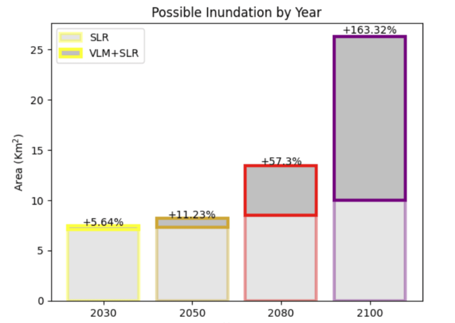
Fig. Bar graph displaying the area at risk of flooding at 2030 - 2100. The upper boxes indicate the additional flooded area when Vertical Land Motion (VLM) is accounted for, with a percent increase from the initial, Sea Level Rise (SLR) only value.
The team used data and models to project coastal flooding down to the millimeter resolution in some places, and they made predictions with and without vertical land motion included.
By projecting current vertical land motion into the future, the authors can narrow down which areas of the city may be at greater risk of flooding, and emergency managers could alert residents early. The study suggests that areas with the greatest amount of subsidence around Lagos are in less populated areas— good news.
The work is still in progress, but Johnson hopes to publish the results soon. Future work will include applying the same methods to different coastal cities around the world.
“We're using a lot of different datasets and there are a lot of different sizes, so there are still uncertainties,” said Johnson. “Eventually, I’d love to get this to a point where local governments or insurance can use this tool.”
To learn more about Joel Johnson's work click here to see his AGU23 poster.
